To prepare for bushfires, you can understand your bushfire risk, take steps to prepare yourself and your property.
Enter your postcode or suburb in the map below to see the bushfire potential in your neighbourhood.
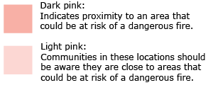
The map does not indicate current bushfires or predict the chances of a fire occurring. It shows the potential for a bushfire to take hold, spread and do damage, if one started in the area. It is based on local conditions such as vegetation type, topography and other indicators.

Use the search bar to check on your loved ones or other areas you frequent.
The mapping considers terrain, vegetation and elevated fire weather.