This page displays information on scheduled Hazard Reduction Burns for Queensland.
What is a hazard reduction burn?
Hazard reduction burns are one of the ways we can mitigate the potential impact of a bushfire in the community. They are carried out before a bushfire starts. Essentially, it is a controlled fire that burns some of the fuel on a property, so when a bushfire crosses your path, there is less fuel for it to feed on.
It's one of the many tools we, and our partners, can use to try and limit the intensity and severity of bushfires.
What should I expect during a hazard reduction burn?
Smoke may impact residents and visitors to the area. Residents in the nearby surrounding areas should close windows and doors and if suffering from a respiratory condition, keep medications close by. Smoke can decrease visibility on the roads, so motorists are urged to drive with caution and to conditions.
Please note: The activities on this page rely on information from external sources and may not be complete. If there are no hazard reduction burns listed below, hazard reduction burning activities may still be occurring. If you are concerned about smoke in your area, please check the Queensland Fire Department’s Current warnings and incidents page to see if a warning is current and/or the Permit to Burn page for registered permits in your area. If you or others are in immediate danger, please contact Triple Zero (000).
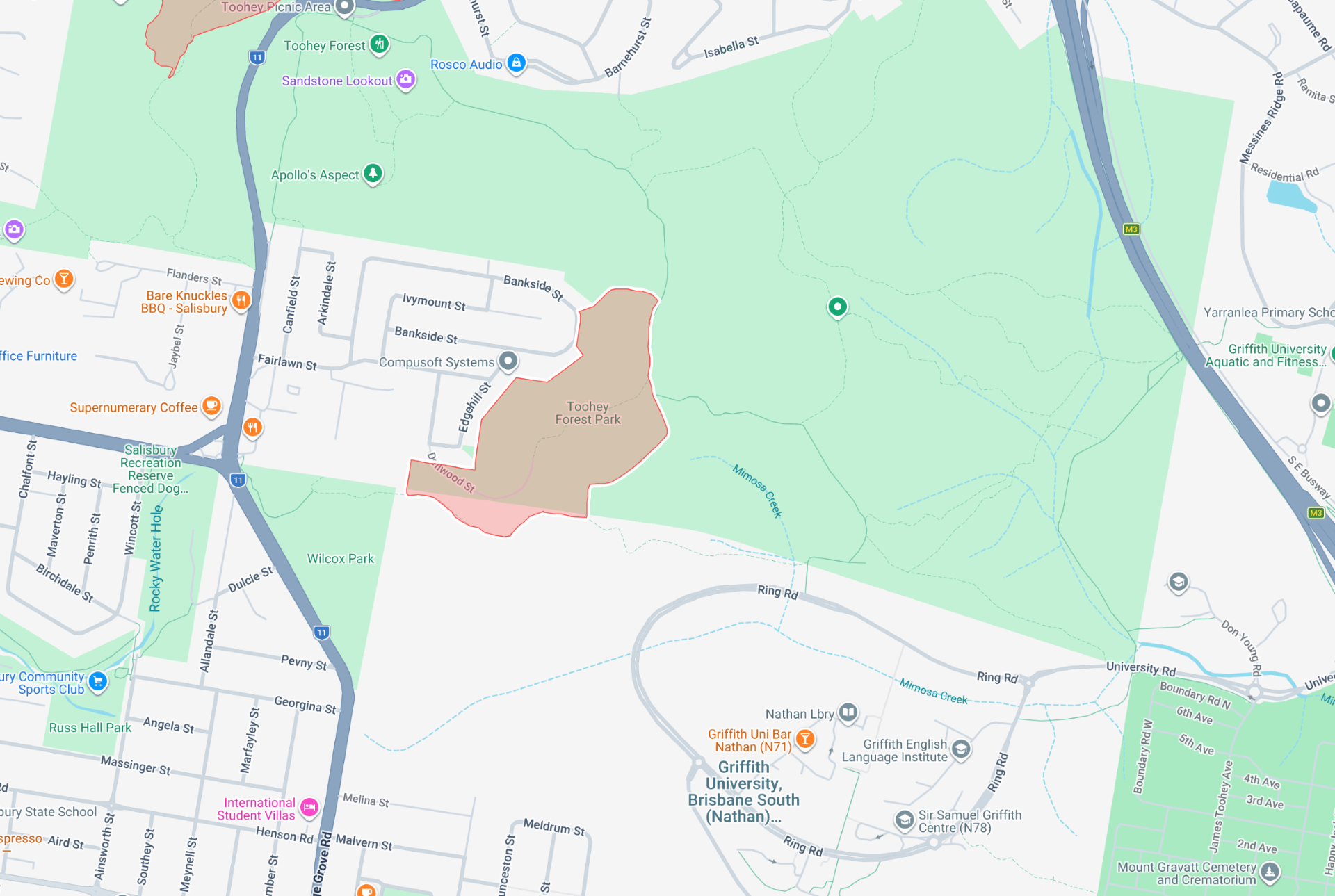
Planned Burn - Toohey Forest, Nathan
Brisbane City Council will be undertaking the following planned burn on Saturday 6 June 2026 (subject to final weather and site checks on Saturday morning)
Reserve: Toohey Forest, Nathan
Block: 23
Area: 16.6 ha
Locality: This burn is located in Toohey Forest between Toohey Ridge Track and behind residences on Edgehill Street and Bankside Street, Nathan.
Expected duration:
This burn will commence at approximately 10 am and continue into the early evening. There will be a small number of staff on site prior to this to check for wildlife in the area. Please note that the burn area will continue to generate smoke even after burn operations are completed. Council staff will not depart site until the burn area is safe. QFD will be notified of the fire status when Council staff depart site. Staff will also be on site on Sunday to ensure the safety of the area.
Smoke dispersal:
Smoke may impact local residences and settle in surrounding areas overnight. The Hibbertia Track, Dellwood Track, Nathan Ridge Track, and Wilcox Track will be closed during the burn and may be closed for up to two weeks after the burn.
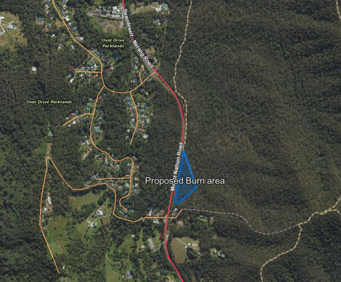
Hazard Reduction Burn: Nerang National Park, Mount Nathan Road
Please be advised that on behalf of The Department of Environment, Tourism, Science and Innovation (DETSI), Queensland Parks and Wildlife Service and Partnerships (QPWS&P) intends to conduct a hazard reduction burn at Nerang National Park (Lot 224 NPW804). The attached map indicates the burn location and extent.
Details on the hazard reduction burn are as follows:
Where: Nerang National Park, Mount Nathan Road, Mount Nathan QLD 4221
When: Friday morning 5 June 2026 (weather permitting)
Notifications: QPWS&P have notified external stakeholders and identified potentially vulnerable facilities and residents adjacent to the hazard reduction burn site. Smoke Hazard signs will remain active until Sunday 7th of June 2026.
Note that following the burn, the site and surrounds will be closed until deemed safe.
Hazard Reduction Burn: Mitchell – West of the Township, Warrego Highway
Please be advised that the Rural Fire Service Queensland (RFSQ) and Queensland Fire and Rescue (QFR) will be conducting a planned hazard reduction burn.
Hazard Reduction Burn Details
Location: Mitchell – West of the Township, Warrego Highway
Date: 6 June 2026
Time: Crews will be onsite from 9:30 am, with ignition expected shortly after. The burns, covering three sites, are anticipated to last approximately 8 hours but will continue until deemed safe.
Permit Number: H 645344 (expiry: 30 August 2026)
Size: Approximately 60 hectares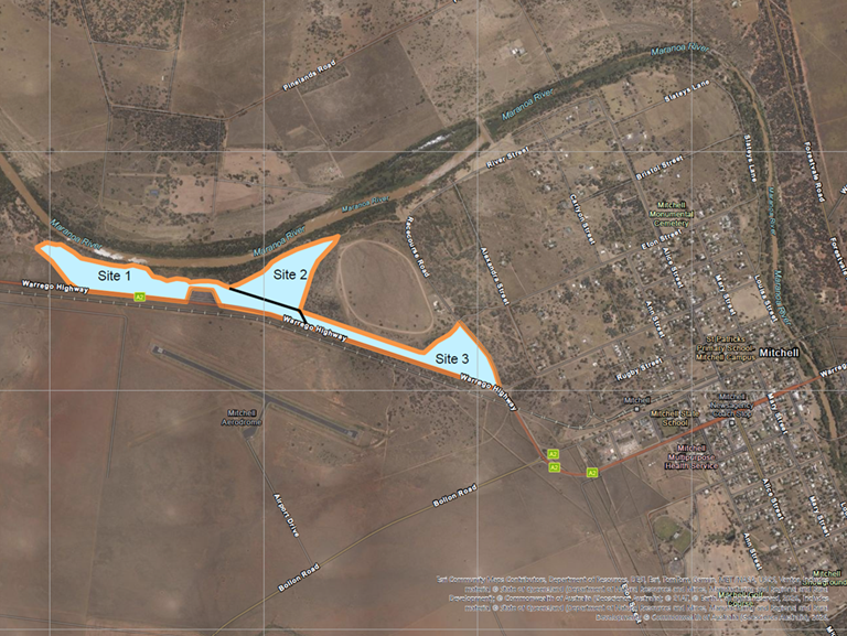
Planned Burn: Wearing Park, 40 Holyrood Court, Munruben
Logan City Council’s Natural Areas - Operations Team will be conducting a planned burn within Wearing Park on Saturday 6 June 2026, weather permitting, as part of our Annual Planned Burn Program. The size of this burn will be approximately 8.5 hectares within Wearing Park.
The approximate extent of the burn site is indicated in blue on the map image below: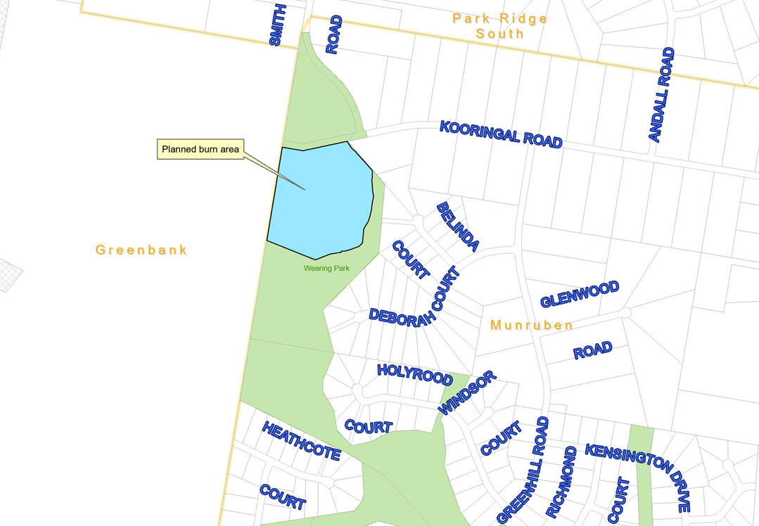
All land management agencies in Queensland have an obligation to mitigate the risk of fire entering or leaving land it owns or manages. Logan City Council achieves this through the implementation of its Fire Management Program which includes the construction & maintenance of firebreaks, fuel reduction works and the undertaking of planned burns.
Logan City Council’s Planned Burn Program intends to strategically reduce the bushfire hazard in selected areas of parks and reserves throughout the city. The aim of these burns is to reduce levels of bushfire fuel within our Parks and rejuvenate native vegetation. This will assist with reducing the intensity of any subsequent bushfires and provide favourable conditions for regeneration of native vegetation.
During these important operational activities, smoke may be seen in the vicinity of Munruben on Saturday. It is appreciated that this planned burn may cause some inconvenience to local residents, however all attempts will be made to limit the effect of these works on the community.
Staff will be onsite for the duration of operations until the burn is contained, with staff returning to site the following day to ensure the site remains secure following the planned burn.
Updates on the timing of Planned Burns are posted on the Logan City Council Facebook page.
Properties adjoining the site of the burn have received a notification letter as per the requirements in the Permit to Light. The letter also includes an option for residents to download the Early Warning Network app for updates on the timing of the burn or notifications prior to the day of the burn.
For more information, please contact Logan City Council on (07) 3412 3412.
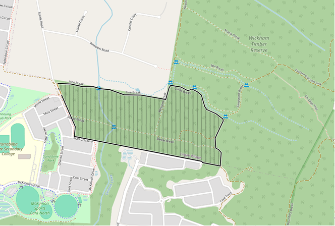
Hazard Reduction Burn: Plunkett Conservation Park
Please be advised that Queensland Parks and Wildlife Service (QPWS) intends to conduct a hazard reduction burn at Plunkett Conservation Park. Please see below map that shows the burn location and extent.
Details on the hazard reduction burn are as follows:
Where: Plunkett Conservation Park
Area: 33 Hectares
When: Saturday 6 June 2026 (weather permitting)
Locality: This burn is located in Plunket Conservation Park between Graham Circuit, Roylen Close, Pineview Road, Steele Road, Dolostone street and Marl Crescent
Notifications: Smoke Hazard signs and closures will remain in place until Monday 8th of June 2026.
This burn will commence at approximately 1500 hours and continue late into the evening. Smoke may impact the surrounding areas of Yarrabilba, Logan Village, Cedar Creek, Tamborine and Jimboomba
Note that following the burn, the site and surrounds will be closed until deemed safe.